Aerial Photography and Transcription
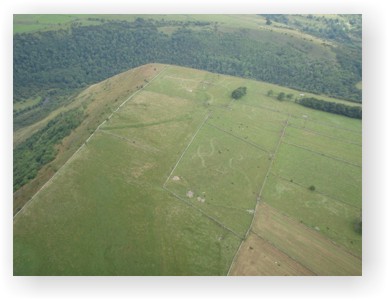 |
Aerial survey is a highly cost-effective technique which enables rapid reconnaissance and detection of archaeological sites over large areas of the landscape. It enables:
-
Discovery of new sites and evaluation of the archaeological potential of a given area
-
Cataloguing, archiving and making these photographs accessible
-
Creating maps and records based on aerial photographs and linking these with information derived from other source.
-
Analysis and synthesis leading to the publication of these survey results
Many areas of the country have so far been subjected to only minimal aerial reconnaissance and transcription. Although much work has been carried out in recent years under English Heritage's National Mapping Programme (NMP) large areas of the country have not yet been mapped. By using infromation from existing aerial photograph archives, the presence of archaeological monuments on development sites can be identified in advance and thereby allow for a better understanding of risk and it's subsequent management as part of larger-scale development.
The appearance of cropmarks and soilmarks is highly dependent on weather conditions and agricultural regimes. Particular combinations of conditions suitable for detection of archaeological sites may occur only briefly and not reoccur for many years. This is an especially relevant consideration given the widely acknowledged effects of climate change. Climate change is presently directly affecting soil moisture deficit, crop type and growth cycle, harvest regimes and snowfall, all of which are of relevance to aerial survey.
Our professional staff are fully qualified in all aspects of air photo interpretation and transcription, and all of our transcription work is undertaken in strict accordance with English Heritage policy and guidelines to NMP standard. We also offer an aerial photography service which provides a cost-effective and rapid way of evaluating and area of landscape in advance of development. Please contact one of our senior archaeologists for further information.